27-30 December 2022 , Kirehe , Rwanda as part of the GCF NAP (National Adaptation Plan) Readiness and Preparatory Support for Building Flood Resilience Capacities in Rwanda Project , a delegation comprising of GGGI Rwanda, Rwanda Environment Management Authority (REMA) and National Lands Authority (NLA) lead a mission to Kirehe Secondary City for the training on Application of Nature Based Solutions (NBS) for flood risk management to Support Inclusive, Climate Resilient secondary cities development in Kirehe Secondary City
The mission was conducted as part of the implementation of the GCF (Green Climate Fund) NAP readiness project to build flood resilience capacities in Rwanda aimed at increasing climate resilience and adaptation of the urban built environment, with an objective of building the Kirehe district climate change resilience through exploration of the land use planning process alongside flood risk assessment, with provided opportunities for capacity building and hands on practices for University of Rwanda students and Rwanda Young Water Professionals.
In his welcome remarks Mr Modeste NZIRABATINYA, The Vice Mayor for economic development/Kirehe District gave an overview presentation of :
1. the district profile as secondary city in phase 2 of the implementation of the National Land use and development masterplan,
2. The district is proactive in strategic planning and stakeholders’ mobilization, different study tours to other secondary cities and city of Kigali for its readiness to be developed as a secondary city,
3. It is committed to engage with all stakeholders we can’t wait for central government earmarks for second phase of secondary cities development by 2035,
4. The district has undertaken urban infrastructure development of roads and residential site servicing,
5. Among District potentialities are (1) agriculture –fertile soil and modern irrigation system, (2) cross-border trade and services, (3) growing private sector, construction sector, (4) Mahama cash-based refugee camp that increase the purchasing power
6. The district is developing two concept paper – Green Kirehe and Logistic hub – Kirehe want to be developed as logistic hub linking the Dar Es Salaam port to Kigali
7. The land use planning is key to guide the investment, reduce development, and land uses conflicts – The district need a specific TA in urban planning i.e. URBAN PLANNER professional
Furthermore Mr Leopold Munyaneza – NLA (National Land Authority) explained how GGGI is support on flood risk management is timely provided as NLA has the issue of mainstreaming this theme into the Kirehe District Land use plan, as they are looking for the outcomes of the mission to be provided as soon as December 2022 to meet the planning timelines
Mr Pelagie Mukaneza, Vice chairperson/Kirehe District Council gave his appreciation of the participatory planning approach adopted by the NLA and the District in the planning process ;the masterplan is expected to reduce land ownership conflict and increased district revenue and the issue of existing development that may not conform to the new planning aspirations that need to be considered
The following presentations were made followed by a group discussion:
Green building – 75% of housing stocks are yet to be constructed and mostly it will be constructed in developing countries including Rwanda and its cities. Hence the need for proactive actions to ensure resources efficiency and avoid emissions for construction sector and buildings in general – The Green Building Minimum Compliance System adopted Rwanda is an example of commitment and District need to implement it at grassroot levels.
Integrating climate action into urban planning – urban development is not a choice, but it happens following the global development trends and Kirehe must expect the same and be proactive in planning to accommodate the growing urban population and demand for socio-economic services and facilities – water, energy, waste management, transport, etc. Poor land use allocations result into poor access to development opportunities and service, and these have a negative impact on increased emissions from motorized transport. A good plan must promote mixed land uses and increase access to jobs opportunities and facilities
Natural Based Solutions – Flood risk modeling and impact of introducing Nature Based Solutions in reduction of water flow into channels. The Vice Mayor got interested into use of Nature Based Solutions instead of Concrete Pavements to increase water infiltration. He suggested that those NBS should be implemented starting from household levels and be prioritized in infrastructure projects where applicable.
Use of GIS (Geographic Information System) in flood risk management- the analysis covering urban boundaries of Kirehe City demonstrated that 13.3% of the city is susceptible to flooding events based on slop and vegetation cover factors. The DLUP (District Land Use Plan) must consider this factor while allocating land for different uses to prevent such events to happen in the future
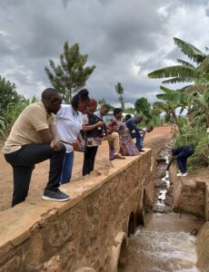
The team was also conducted field visits to the Nasho sub-catchment as the catchment is susceptible to flooding downstream close to the irrigation system mainly due to water channels capacities. It is affecting settlements and farming areas. Preliminary data were collected by the RWYP team to propose alternative solutions with focus on NBS where possible. The next site visit was to the Urban open and public spaces – a team from University of Rwanda school of architect and built environment visited the proposed open and public spaces to collect preliminary data for urban spaces designs proposals development
Mr Bruno RANGIRA, The mayor of Kirehe District gave his closing remarks highlighting the Eastern part of the country is absorbing the bigger part of migrants from other parts of the country (North, West, South) including Kirehe and the district is aware of that and need to be more proactive in planning to accommodate the increasing population, he further thanked GGGI for the follow up mission after meeting the Country Representative and recognized the role to be played by GGGI in the development climate resilient city of Kirehe ; and the assessment of flood risk and management will be key for the growing city of Kirehe and its surroundings including agricultural lands. For example, Nasho irrigation areas has a water table which is close to the surface area and need to be managed carefully , adding that out of 12 sectors of Kirehe, 7 of them share boundaries with Akagera river. The riverbanks and buffer zones need to be protected
Afforestation is needed to increase the vegetation cover with focus on indigenous species that are adapted to the region
Mr Leopold Munyaneza – NLA said that the flood risk management modelling will highly contribute to the planning especially in the settlement and storm water management and that the open public spaces mapping is also key as we need to meet the SDGs (Sustainable Development Goals) targets and propose new ones where possible
During the mission the following observations were also made that the
- The city has done well in roads design that includes cycling and pedestrian routes. This is considered as public spaces and needs to be also considered in planning and city development. For example, the city is suitable for public bike sharing
- A cycling training site is proposed to attract touristic activities
- The city is planned as linear, and this has negative impact on emissions and low connectivity
- The masterplan must consider social aspect including cemeteries